Chinese name: 长江 (Cháng Jiāng)
Other names: Yangtse River, Yangzi River, Yangtze Kiang
Length: 6,380 km (3,964 miles)
Source: Glacier of Jianggendiru, west to the Geladandong Peak, the main peak of Tanggula Mountain
Source elevation: 5,042 m (16,542 ft)
Location: 24°30′-35°45′N, 90°33′-112°25′E
Influx into: China East Sea
Average discharge: 31,900 cubic meters per second (1,127,000 cubic foot per second)
River basin: 1,800,000 square km (694,983 square miles)
Yangtze River is the largest river in China and the third longest river in the world, next to the Nile in Africa and the Amazon in South America. Rising in Tanggula Mountain, the Yangtze River flows eastwards and pours itself into the East China Sea. Measuring about 6,380 km (3,964 miles), it mainly runs across Qinghai-Tibet Plateau, Sichuan, Yunnan, Chongqing, Hubei, Hunan, Jiangxi, Anhui, Jiangsu and Shanghai from west to east.
 Yangtze River Basin is a big granary of China. The grain it produces covers a half of the whole nation, of which the rice accounts for 70% in the total. Other crops such as cotton, barley, wheat, maize and bean are also produced in the area. Besides, it is the most prosperous and densely populated area in the country. The important cities with a population of over one million such as Shanghai, Nanjing, Wuhan, Chongqing and Chengdu are located in the area. Same as the Yellow River, Yangtze River is also the cradle of Chinese civilization. It is endowed with long history and abundant cultural relics.
 Major Cities along Yangtze River
Panzhihua, Yibin, Luzhou, Chongqing, Fengdu, Wuhan, Yichang, Jingzhou, Shashi, Shishou, Ezhou, Xianning, Huangshi, Huanggang, Yueyang, Hefei, Chaohu, Chizhou, Anqing, Tongling, Wuhu, Chuzhou, Maanshan, Jiujiang, Nanjing, Suzhou, Yangzhou, Zhenjiang, Jiangyin, Nantong, Taizhou, Shanghai
Water Network
The water network of the Yangtze River covers about 1,800,000 square km (694,983 square miles), accounting for 18.8% of the land area in China. The upper stream of the Yangtze River is between Yibin City in Sichuan Province and Yichang City in Hubei Province. It is also called Chuan River because most parts flows through Sichuan Province. The river in this section has many shoals and rapids. The famous scenic sight "Three Gorges" is located here. The middle stream starts from Yichang City to Jiujiang City in Jiangxi Province. The river system is highly developed in the area. Many lakes are scattered around. The section between Yidu City in Hubei Province and Chenglingji Harbor in Yueyang City in Hunan Province is called Jingjiang because it passes the ancient Jingzhou area. The down stream refers to the main river section between Jiujiang and Shanghai. Originally, "Yangtze" was the name of this river section due to the ancient Yangzijin Ferry in the area.
Yangtze River has numerous tributaries, merging into the river and forming great water source to it. There are 49 tributaries whose basin area surpasses 10,000 square km (3,861 square miles). The main ones are Hanjiang River, Yalong River, Minjiang River, Jialing River, Wujiang River, Xiangjiang River, Yuanjiang River and Ganjiang River. The famous Huangpu River in Shanghai, not as large as the former ones although, is also a tributary of the Yangtze River. Big lakes in the Yangtze Basin include Dongting Lake, Poyang Lake,Taihu Lake, Liangzi Lake, Chaohu Lake and Honghu Lake.
Irrigation Projects
 The earliest irrigation project on Yangtze River is Dujiangyan Irrigation Project. Located on Minjiang River, west to Chengdu City, it is the oldest and existing no-dam irrigation system in the world.
In 1988, the construction of the first big dam on Yangtze River -Gezhouba Dam was finished. It creates the effects of generating electricity and improving the gorge river channel. In 2009, another big dam - the Three Gorges Dam was completed. Located near Sandouping Town in Yichang City, Hubei Province, it is the largest hydropower project, the most efficient dam in flood control and the largest migration project in the world. The two dams together produce a marked effect to the power generation, flood control, navigation and tourism in the middle and upper reaches of the Yangtze River.
Crossings
Before the founding of People's Republic of China, the transportation across the Yangtze River reckoned only on the ferry which brought much inconvenience. In 1957, the first big bridge across the river –Wuhan Yangtze River Bridge was completed and opened to traffic. Later many big bridges both on the main streams and the branches of the Yangtze River were constructed, including the famous ones in Chongqing, Wuhan, Jiujiang, Nanjing and Shanghai etc. Now there are hundreds of bridges on the Yangtze. On Dec.28 2008, Wuhan Yangtze River Crossing Tunnel, the first of its kind in Yangtze River was opened to traffic. Shanghai Yangtze River Tunnel has been in operation since Oct. 31 2009.
Other names: Yangtse River, Yangzi River, Yangtze Kiang
Length: 6,380 km (3,964 miles)
Source: Glacier of Jianggendiru, west to the Geladandong Peak, the main peak of Tanggula Mountain
Source elevation: 5,042 m (16,542 ft)
Location: 24°30′-35°45′N, 90°33′-112°25′E
Influx into: China East Sea
Average discharge: 31,900 cubic meters per second (1,127,000 cubic foot per second)
River basin: 1,800,000 square km (694,983 square miles)
Yangtze River is the largest river in China and the third longest river in the world, next to the Nile in Africa and the Amazon in South America. Rising in Tanggula Mountain, the Yangtze River flows eastwards and pours itself into the East China Sea. Measuring about 6,380 km (3,964 miles), it mainly runs across Qinghai-Tibet Plateau, Sichuan, Yunnan, Chongqing, Hubei, Hunan, Jiangxi, Anhui, Jiangsu and Shanghai from west to east.
Yangtze River Basin is a big granary of China. The grain it produces covers a half of the whole nation, of which the rice accounts for 70% in the total. Other crops such as cotton, barley, wheat, maize and bean are also produced in the area. Besides, it is the most prosperous and densely populated area in the country. The important cities with a population of over one million such as Shanghai, Nanjing, Wuhan, Chongqing and Chengdu are located in the area. Same as the Yellow River, Yangtze River is also the cradle of Chinese civilization. It is endowed with long history and abundant cultural relics.Panzhihua, Yibin, Luzhou, Chongqing, Fengdu, Wuhan, Yichang, Jingzhou, Shashi, Shishou, Ezhou, Xianning, Huangshi, Huanggang, Yueyang, Hefei, Chaohu, Chizhou, Anqing, Tongling, Wuhu, Chuzhou, Maanshan, Jiujiang, Nanjing, Suzhou, Yangzhou, Zhenjiang, Jiangyin, Nantong, Taizhou, Shanghai
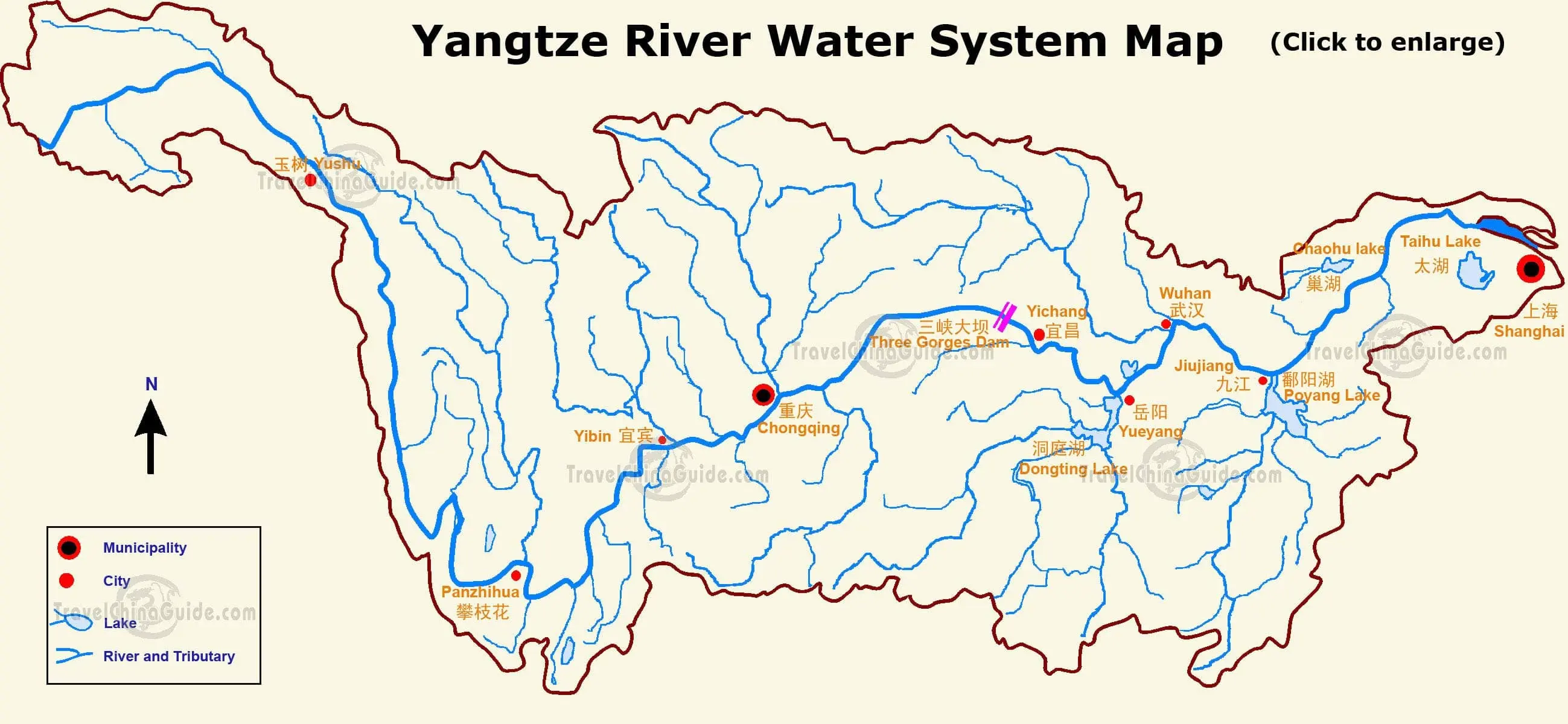 |
| Yangtze Water System Map (Click the map to enlarge it) |
Yangtze River has numerous tributaries, merging into the river and forming great water source to it. There are 49 tributaries whose basin area surpasses 10,000 square km (3,861 square miles). The main ones are Hanjiang River, Yalong River, Minjiang River, Jialing River, Wujiang River, Xiangjiang River, Yuanjiang River and Ganjiang River. The famous Huangpu River in Shanghai, not as large as the former ones although, is also a tributary of the Yangtze River. Big lakes in the Yangtze Basin include Dongting Lake, Poyang Lake,Taihu Lake, Liangzi Lake, Chaohu Lake and Honghu Lake.
The earliest irrigation project on Yangtze River is Dujiangyan Irrigation Project. Located on Minjiang River, west to Chengdu City, it is the oldest and existing no-dam irrigation system in the world.In 1988, the construction of the first big dam on Yangtze River -Gezhouba Dam was finished. It creates the effects of generating electricity and improving the gorge river channel. In 2009, another big dam - the Three Gorges Dam was completed. Located near Sandouping Town in Yichang City, Hubei Province, it is the largest hydropower project, the most efficient dam in flood control and the largest migration project in the world. The two dams together produce a marked effect to the power generation, flood control, navigation and tourism in the middle and upper reaches of the Yangtze River.
Before the founding of People's Republic of China, the transportation across the Yangtze River reckoned only on the ferry which brought much inconvenience. In 1957, the first big bridge across the river –Wuhan Yangtze River Bridge was completed and opened to traffic. Later many big bridges both on the main streams and the branches of the Yangtze River were constructed, including the famous ones in Chongqing, Wuhan, Jiujiang, Nanjing and Shanghai etc. Now there are hundreds of bridges on the Yangtze. On Dec.28 2008, Wuhan Yangtze River Crossing Tunnel, the first of its kind in Yangtze River was opened to traffic. Shanghai Yangtze River Tunnel has been in operation since Oct. 31 2009.
2010-12-14
Xuxifenglily
没有评论:
发表评论